Reconnected Floodplain
Organization: KUEI/FAU (Germany)
Floodplain re-connection by technical re-establishment of hydrologic dynamics and restoring of ecological functions along a stretch of the Upper Danube in Bavaria, Germany (KUEI).
General Overview
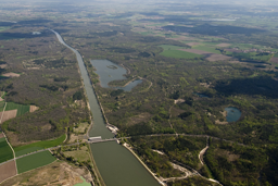
The pilot site DPS2 is situated between the Bergheim barrage and Ingolstadt on the left side of the Danube, encompassing an approximately 8 km stretch of a vast 2,100 ha floodplain forest area in Bavaria. This area constitutes one of the largest contiguous floodplain forest complexes in Germany. The Danube, a 1st order water body, serves as the border between the natural landscapes of the Alpine foothills and the German low mountain ranges. The discharge of the Danube is significantly influenced by the alpine tributaries Iller and Lech, resulting in frequent floods in early summer and periods of low water in late fall and early winter.
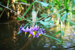
Ecological flooding may occur in the project area during periods of high water levels in the Danube, especially when carrying snowmelt from the Alps. The Danube valley is identified as a distinct fluvio-glacial natural area, including the Danube moss in the Ingolstadt basin to the south. The Danube floodplains are categorized as "river floodplains of the foothills of the Alps, rich in precipitation, with summer floods, gravel/gravel-dominated."
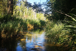
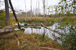
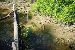
Besides the Danube, other significant surface waters include the Längenmühlbach and the Zeller Canal, both influenced by periodic water flow and precipitation. The "Old Danube," the largest oxbow in the area, is a former river loop largely disconnected from the Danube but reconnected through a dynamization project. Numerous ponds, flood channel systems, and large lakes formed by gravel mining are present, contributing to the diverse water features in the study area.
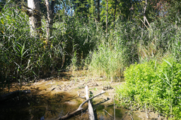
Hydromorphological considerations, including soil properties and aquiclude layers, are crucial for effective renaturation measures. The pilot area holds international significance as a landscape conservation area, designated as part of the European biotope network NATURA 2000 (FFH and SPA area). It also includes water protection areas and is recognized as "Official Biotopes," covering around 90% of the project area with diverse ecosystems like forests, water bodies, reed beds, and burns.
Implemented measures
The Free State of Bavaria undertook the "Dynamization of the Danube floodplains between Neuburg and Ingolstadt" project in response to significant changes in the Danube and their adverse effects. Initiated by the Ingolstadt Water Management Office in 2005, the project aimed to address negative impacts by implementing measures to restore floodplain conditions. Completed in 2011, the project involved three key measures.
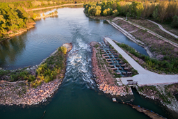
Firstly, an approximately eight-kilometer-long watercourse/detour structure (Ottheinrichbach) was constructed. This structure aimed to restore continuity, groundwater dynamics, and cross-linking of the Danube with its floodplain area by connecting the headwaters and tailwaters of the Bergheim barrage. The Ottheinrichbach serves as a bypass watercourse for fish, contributing to the reactivation of floodplain-typical conditions.
The second measure involved the reconstruction of the overspill weir at the Bergheim barrage to enable ecological floodings. Controlled small floods, known as "flood pulses," were released to mimic natural floodplain dynamics, enhance diversity, and structure the floodplain forest. The overspill weir facilitated channeling up to 25 m³/s of Danube water into the Längenmühlbach for ecological floodings.
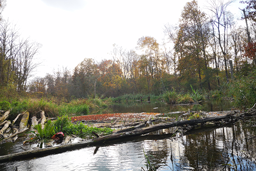
The third measure focused on groundwater lowering, achieved through the construction of a 2.1 km drainage ditch. This measure aimed to increase groundwater fluctuations in the eastern project area and lower unnaturally high groundwater levels resulting from the construction of the barrage. Groundwater management replicated natural dry phases, promoting the development of alternating water zones, particularly in the "Old Danube."
By combining these measures, the project sought to recreate dynamic water conditions, ensure continuity for aquatic life, and restore the connection between the Danube and its floodplain. The ultimate goal was to return the floodplains to their pre-regulation state from the 19th century, despite the project group considering full restoration unrealistic.
Impact of the measures on the environment
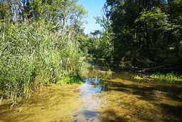
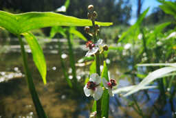
The "Dynamization of the Danube floodplains between Neuburg and Ingolstadt" project has yielded profound impacts across various domains, encompassing vegetation, hydromorphology, water quality, groundwater dynamics, and wildlife corridors for fishes and fauna. The project has been notably successful in rejuvenating the ecosystem. In terms of vegetation, discernible shifts in species composition along transects and monitoring plots were observed, particularly influenced by the water level of the Ottheinrichbach, fostering positive responses in aquatic and riparian vegetation. Hydromorphological changes, including sediment rearrangement and the near-natural course development of Ottheinrichbach, have led to habitat modifications and the formation of structures contributing to natural sand and gravel bars. The impact on water quality and groundwater dynamics resulted in significant fluctuations, positively affecting vegetation and floodplain stages. Wildlife corridors and fauna also thrived, with fish passes and ecological floodings enhancing fish habitats and supporting terrestrial fauna, indicating increased biodiversity. Overall, the combined impact of these restoration measures has been highly successful, achieving the project's goals and demonstrating the potency of a comprehensive approach to enhancing ecosystem health and functionality.
Summary and recommendations
The "Dynamization of the Danube floodplains" project, situated between Neuburg and Ingolstadt, has successfully introduced a "controlled floodplain dynamic," yielding positive outcomes for the overall health and diversity of the ecosystem. Although the current state is not entirely self-regulating or sustainable concerning runoff, it signifies a substantial improvement from the previous regulated conditions. The dynamization efforts have, to some extent, compensated for the ecosystem functions lost due to dam regulation in the Ottheinrichbach area, alleviating the impacts of barrage construction. Recognizing these accomplishments, it is acknowledged that the transformation from a semi-terrestrial floodplain forest ecosystem to a terrestrial forest ecosystem cannot be fully reversed for complete renaturation. To enhance positive development, recommendations include optimizing dynamization measures to promote floodplain-typical plant species, increasing water level fluctuations, especially in extreme areas, and introducing mechanical disturbances. Furthermore, enhancing ecological flooding with larger water amounts over extended periods is proposed to foster floodplain-typical dynamics. The targeted release of organisms, such as planting or stocking, is suggested to support restoration efforts, considering the varied dispersal abilities of floodplain vegetation and mollusks. Advanced management strategies for fish fauna, including the development of new supply biotopes and potential stocking with appropriate species, are recommended to address the apparent exhaustion of the Danube's supply biotope. In conclusion, these recommendations aim to sustain and augment the positive ecological developments initiated by the dynamization project, promoting biodiversity and ensuring the long-term restoration of the floodplain ecosystem.